 "It all begins with the Map!"
GeoElections News
 Temple Terrace, FL www.icwmaps.com VOL. 10 NO.1 -
  $.50
$.50 
|
12th Annual GeoElections® Conference December 4th, 5th, and 6th, 2013 at the Embassy Suites Hotel located at the University of South Florida will provide work shops
Guest Speakers Invited and presentations on topics of latest versions of MapInfo Professional, GeoAuthor, and Elections. While the agenda has not been locked down, your suggestions for presentations on specific topics are invited. This is your conference. Let’s work to make it content rich. There is no event like the GeoElections Conference. We focus upon the successful use of GIS in the elections process dictated by the best practices in elections administration. ICW is looking for users to speak about creative ways they have used GeoElections to meet the operational objectives of their offices. For more information about the GeoElections Conference visit our web site: www.icwmaps.com and click Events>Conference to obtain a Registration Form and Topic Survey.
Hope to see you in December!
PBSI has released MapInfo Professional Version 12.01. New features include new scale bar options, cartographic scale options, a new way to align layout objects, and new features in the Legend Designer, as well an update to the Universal Translator. The goal of these features is to improve the ease with which you can create high-quality output from MapInfo Professional (MI Pro). MI Pro is compatible with both Windows versions 7 and 8. ICW has been an authorized reseller of MI Pro since 1988 when it was origionally sold as MapInfo by MapInfo Corporation. Annual Dinner and A Movie Is Scheduled For MOSI Located at the opposite end of the Campus from the conference hotel is Tampa's Museum of Science and Industry (MOSI). 6:00 to 10:00 PM on the 8th at MOSI, dinner and a movie. MOSI is a 74-acre campus incorporating an interactive science center with more than 450 hands-on exhibits contained in over 300,000 sq. ft. There is also a public library, a planetarium and Florida's only IMAX Dome Theater.
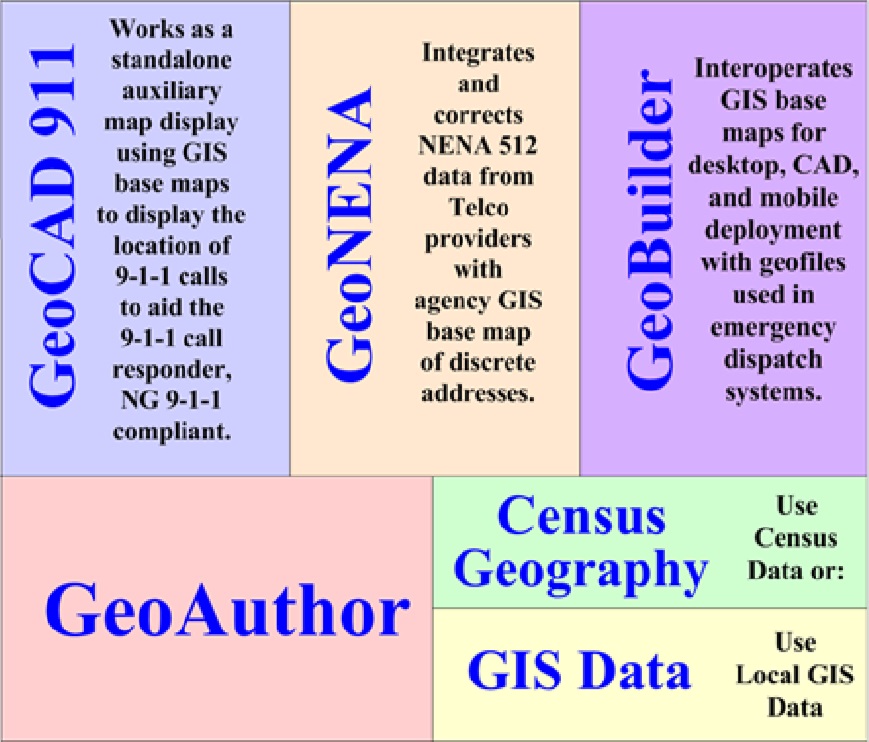
GeoAuthor® Is Prime Time For E-9-1-1 GeoAuthor 1st released in 2005 as the successor to MapEdit has received the numerous feature enhancements over the last 8 years to extend and leverage the functionality of the original design. Envisioned as a means to bridge the demands for updating TIGER/Line Shape Files, it soon became apparent ICW had to facilitate editing non-TIGER data typically produced by local GIS departments. ICW First developed an application for E-9-1-1 dispatch for the City of Akron, OH in 1997 which interoperated with their CAD system. Since that time ICW has developed numerous modules for public safety as illustrated in the block diagram.
When building a base map from TIGER/Line Shape Files for use in election’s, conflating data from local 9-1-1 files is a tremendous aid along with parcel maps, local GIS data, aerial photographs, USPS.gov, and even google maps, etc. The use of GeoAuthor® in public safety benefits elections. |
|
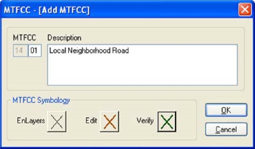
GeoAuthor® Version 2.3 Released and Available for Installation From www.icwmaps.com>Downloads Two significant enhancements to GeoElections are included in with Version 2.3 of GeoAuthor: 1. MTFCC presents the user with a default list of MAF TIGER Feature Classification Codes along with their associated graphical symbology. The user can edit the default symbol for any feature and add new features defining their symbology. 2. Backup presents the user with a fast and efficient means to save key folders or the entire project as a compressed file in the TRGBack folder contained within the project. 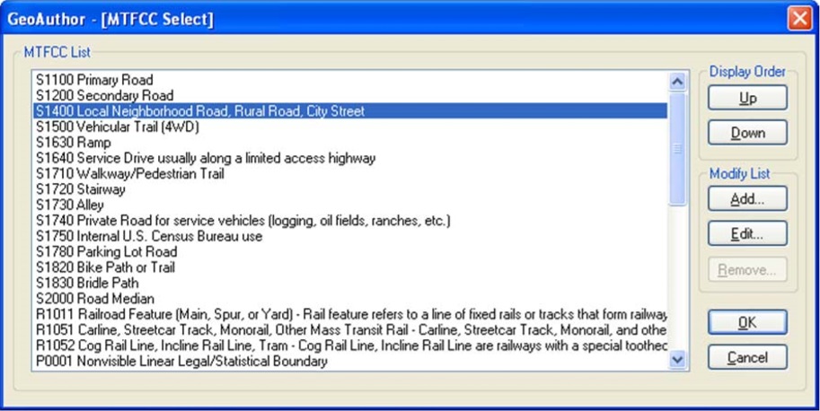
Every line segment in the database has an MTFCC value. MTFCC stands for MAF TIGER Feature Classification Code. Prior versions of TIGER used CFCC codes. GeoAuthor uses the MTFCC code for each line segment to determine how to graphically symbolize the segment and the layer in which the segment should be included when running Build Layers. The GeoAuthor>Preferences> MTFCC command sequence presents the user with the GeoAuthor – [MTFCC Select]. The user may select a code to
Running Build Layers, lines with this definition will appear as symbolized by the end-user. 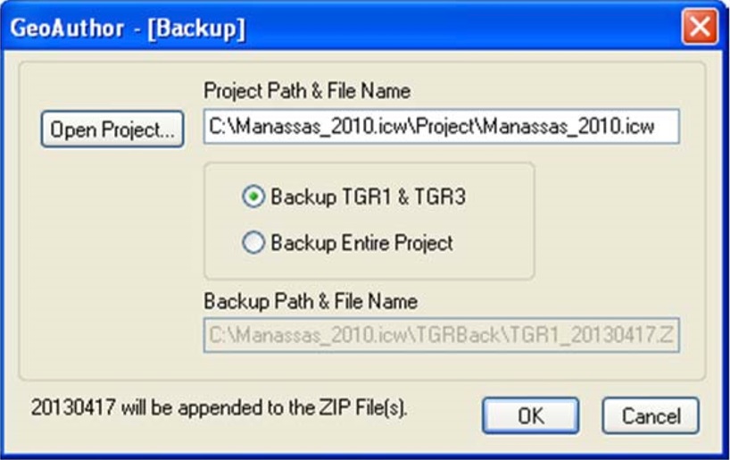 The GeoAuthor>Table Maintenance>Backup command sequence presents the user with the GeoAuthor – [Backup] dialog box. Backup provides the user with a quick and efficient means to create a compressed file of two key data folders or the entire project. The Project Path & File Name default to the current project. The Backup Path & File Name is managed by GeoAuthor. Backup will append the YYYYMMDD string to the name of the compressed file and place the resulting compressed file into the TRGBack folder. This utility is not intended to replace alternative backup functions your IT staff may currently have in place to store your work on another computer or network addressable device. Refer to the GeoAuthor User’s Guide for more detailed instructions in the use of these two new features. |