
 "It all begins with the Map!"
International Computer Works, Inc. (ICW) founded in 1988, provides a range of products and services designed to leverage the power of Geographic Information Systems (GIS) technologies. ICW provides customers with GIS consulting support, conversion services, software applications, training, and post-sales support.
The first project undertaken involved services to Dow Jones and Company in the design of a system for their direct marketing department using their National Delivery Service geo-file to sell subscriptions of the Wall Street Journal, Asian Wall Street, Barons and National Employment Weekly. In the summer of 1988.
Our primary facility located at 111 South Riverhills Drive, Temple Terrace, FL, serves as our sales and training center, base of operations of software development, support services and Corporate Headquarters.
In 1995 ICW was awarded a contract from the Secretary of State of Wyoming. The deliverables consisted of the ICW TIGER Update Software (TIGERUS©) and the necessary training to enable representatives of the 23 County Clerks to update TIGER/Line Files. On the success of the Wyoming project, numerous governmental agencies and private firms across the country acquired TIGERUS©. In 2007 ICW introduced a major release of TIGERUS© introduced as GeoAuthor® which includes GeoPoints©.
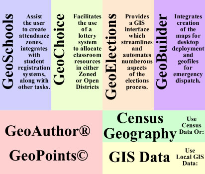
ICW has developed vertical applications integrating GeoAuthor® and GeoPoints© as the foundation upon which the applications illustrated below are built. The enhanced data created with the ICW editing tools combined with these vertical applications, provides a more powerful solution for the end-user than alternatives.
GeoAuthor®, can be used for editing data with and without topology. For example most data created by city or county GIS Departments do not have topology, while the US Census Bureau TIGER/Line Shapefiles depend upon topology. Alternatively, one can use GeoAuthorGT™ (GeoSpatial Topology) with non-topologically stored GIS data to create topology and continue to add and enhance multiple layers to conflate into a single linear network.
Following is a list of applications offered by ICW, which work with GeoAuthor® and GeoPoints©:
The ICW client list is a diverse mix of organizations across the US including elections, public safety, law enforcement and K thru 12 education. The need to visualize, study, and analyze geographically dispersed data with a cost effective GIS has proven to be a universal need. ICW is ideally positioned to contribute to the value of the national treasury of digital geography and education.
For more current information about ICW please refer to our GeoElections® News or contact our corporate headquarters.