
 "It all begins with the Map!"
Exciting news for administrators in redistricting and attendance.
GeoSchools© provides the end-user with an easy-to-use interface that automates and streamlines several useful functions in conjunction with redistricting. GeoSchools© leverages the power of GIS through the use of either GeoAuthor® or GeoAuthorGT™. GeoSchools© was developed to assist school administrators make best practice decisions with GIS data reflective of the communities they serve.
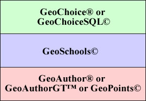
GeoSchools© is a software module that works as a standalone application on top of an ICW editing module or in conjunction with Geochoice and Geochoice. The lego block architecture is illustrated below.
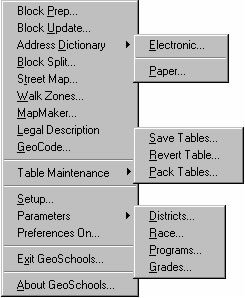
When GeoSchools© is selected from the menu bar, a pull down menu is displayed. An arrow next to a menu item indicates a pop out submenu exists. For illustration purposes we have expanded the complete menu set as displayed below.
At the core of GeoSchools©, there are four groups of tables that are used as input to create new data for the school planner:
The user may select either GeoAuthor® or GeoAuthorGT™ as the GIS editor and database manager to leverage the functionality offered by GeoSchools©. GeoSchools© uses the linear database created and maintained in the map database to create block splits and generate a road table on demand. This road table can be used for geocoding students and testing the latest updates to the map database. Because the road table and the block table are derived from the same database, the geometry of the two files is identical.
| 1. | Block Prep | GeoSchools© adds a series of fields to the block table for purposes of tabulating the demographics of the geocoded student population. These polygons are also encoded with the respective attendance boundaries in which they are contained. |
| 2. | Block Update | After the block table has been modified to accommodate fields for high school, middle school, and elementary school attendance zones and student data, this menu option will count the occurrences of the demographic characteristics per block and record the count. |
| 3. | Address Dictionary | This option has a submenu that permits the type of dictionary to build. A dictionary in either case is an ASCII text file that contains street name, address ranges, and attendance zone information. |
| Electronic will create a file that contains all of the information found in the Paper Dictionary plus longitude and latitude data. | ||
| Paper will create a file that contains records for each side of the street including street name, address range, and attendance zone. | ||
| 4. | Block Split | Allows the user the ability to split a block using a line that is either already in the map database, or that is subsequently added. Upon the execution of the block split, the tabulation of the demographics is automatically adjusted for the new blocks. |
| 5. | Street Map | Builds a street map from the segments in the map database intended for use in geocoding the student table. |
| 6. | Walk Zones | Provides the user with a parameter driven interface with which to identify the streets that fall within walking distance of a given campus. |
| 7. | MapMaker | Creates map layers for the planner from the list of districts in the block table. These can be used for day-to-day applications by other members of staff, publishing to a web site or creating other cartographic products to staff, faculty or families. |
| 8. | Legal Description | Builds a file of legal descriptions for one or more of the boundaries built with MapMaker. |
| 9. | GeoCode | Maps the students, campus locations, bus stops, etc. as symbols along the network of streets. Different than other geocoders, this module uses the 5 digit ZIP Codes that appear as left and right side attributes of the each street segment in the network of streets. |
| 10. | Table Maintenance | Consists of a submenu that provides access to GeoSchools© functions which manage files as opposed to manipulating individual or groups of objects in a table. Following is a list of the items and a brief overview of the functionality represented by this menu group. |
| Save Tables will save multiple tables relieving the user from the need to perform multiple saves. | ||
| Revert Tables will revert multiple tables relieving the user from the need to perform multiple revert table commands. | ||
| Pack Tables will pack multiple tables relieving the user from the need to perform multiple packing operations. | ||
| 11. | Setup | To initiate a work session the user starts with this menu item. This feature allows the user to select a project, the block table, and the geocoded student table. |
| 12. | Parameters | Provides an interface with which the user defines numerous variables used for encoding blocks. |
| 13. | Preferences | Can be turned on or off and work with the block split tool. |
| 14. | Exit GeoSchools | Exits GeoSchools© and/or your GIS application. |
| 15. | About GeoSchools | When the user selects this menu item, a dialog box displays the version and serial number of the active copy of GeoSchools©. |
Call for additional details about GeoSchools©.
