 "It all begins with the Map!"
GeoElections News

 Temple Terrace, FL www.icwmaps.com VOL. 13 NO.2 -
  $.50
$.50 |
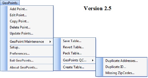
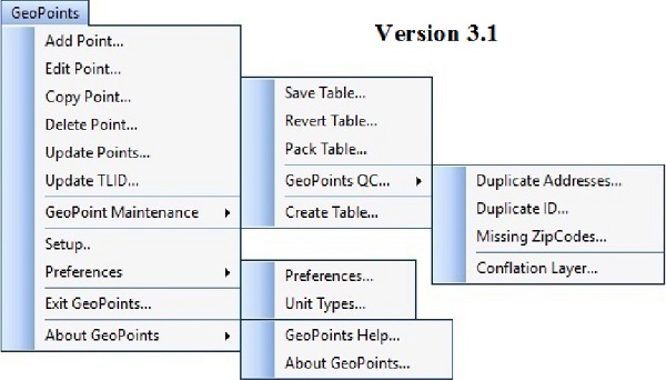
New Features In GeoPoints© Numerous features added to GeoPoints© will assist both existing users and those who will use GeoPoints© in the future. For example: 1. Context sensitive Help has been added to dialog boxes in GeoPoints© 2. Update TLID will update the TLID and New_TLID fields in a selection of points based upon a match of either Street Name or House Number and Street Name getting the values from a matching segment. 3. A Unit Type field has been added. This field can only be filled from a pop-down pick list. The list is maintained by the user in an external table to assure consistency with data entry. 4. Conflation Layer assists the user to convert an externally created point file to the data structure used by GeoPoints©. 5. Add Point was expanded to allow the user to select a point from the conflated file to add directly into the current GeoPoints© file. 6. Unit Types provides an interface for managing the table used in the Unit Type pop-down pick list. 7. GeoPoints© Help provides access to the Getting Started section of the Help file. GeoAuthor® With Major Enhancements for GeoPoints© ICW has released GeoAuthor® 3.1. In addition to an expansion of the context sensitive Help within GeoAuthor®, the GeoPoints© module has received significant feature enhancements to meet the increasing demand for points to augment the functionality of ranged addresses. In many instances GeoPoints© can better represent anomalies with residential addresses and identify commercial structures that may not be eligible for voter registration. At a glance one can see the extensive feature enhancements the GeoPoints© module has received comparing the prior version of the menus to the latest version.
These added features will improve geocoding and facilitate greater accuracy and consistency when importing to VR with the Dictionary.
These enhancements have been added based upon both our client requests and observation of the way clients use GeoPoints©.
|
|
ICW To Offer a GeoAuthor® VTD Edition in 2017 ICW introduced the GeoAuthor VTD Edition software at the GeoElections Conference in November 2008 and again at the FSASE winter conference held in Duval County. Designed to assist clients with participation in the VTD Update Phase for Redistricting 2010, this application proved to be more effective than any alternative. As guest speakers attending a post redistricting Annual GeoElections Conference, both John Guthrie, then staff Director of the Florida Senate Reapportionment Committee and Catherine Clark McCulley, then Chief of the Census Data Redistricting Office, stated; data from county participants who used GeoAuthor® was superior to the data received from county participants who had used the software distributed by the Bureau. ICW staff has been corresponding with individuals at the Data Redistricting Office and Division of Geography to confirm both the data structures intended for use in the 2020 Phase 2 program and the reports the Bureau wants to receive after participants have completed their work.
In 2000 the State of Florida had 362,499 Census Blocks. In 2010 that number had grown to 484,481. For the next decade, 2020, it is expected Florida participation will reduce the number of blocks. The Phase 1 Block Boundary Suggestion Program (BBSP) was intended to give Florida the opportunity to reduce the number. 3 counties have participated in the BBSP. The deadline for submittal of the work is May 31, 2016. Last decade was the first decade in which the State of Florida participated in the Data Redistricting Project. Phase 2 VTD was an outstanding success for the State last decade because of the enthusiastic response of our 67 Offices of Supervisor of Elections. The Phase 2 VTD project will give our SOEs the opportunity to perform block consolidation, feature updates, define the bounds for VTDs, work with municipalities in their respective counties to update municipal boundaries, and much more. The people at ICW look forward to making our VTD Edition of GeoAuthor available to any county in Florida at no charge. Florida is able and should be a model for other states to aspire to emulate regards the outstanding performance expected from 2020 Phase 2 VTD Update Project. |