 "It all begins with the Map!"
GeoElections News
 Temple Terrace, FL www.icwmaps.com VOL. 15 NO.3 -
  $.50
$.50 
GeoElections Is Introduced At The
ESRI USER CONFERENCE 2018
|
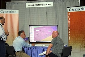
GeoElections for ArcMap was unveiled at the 2018 Esri User Conference conducted at the San Diego Convention Center. Demonstrations were well received with interests from both domestic and international attendees. International Computer Works, Inc. occupied booth 440 in the exhibit hall. Interactive demonstrations of GeoAuthor, GeoPoints and GeoElections engaged attendees with a variety of backgrounds from academia, E911 professionals, county GIS officials, elections staff and Esri staff.
This was the first Esri User Conference staff from ICW attended and the magnitude of attendees and number of vendors in the exhibit hall was impressive. There was an estimated 18,000 attendees from over 130 countries with a wide array of professional interests relating to the use of GIS.
GeoAuthor, GeoPoints and GeoElections proved to be a unique product set at the conference. The interoperability of GeoElections with voter registration systems, along with the numerous features included in the product set, distinguished the ICW offering from any other vertical application running on ArcMap. The design of GeoElections captures the power of ArcMap and focuses that power to address the numerous tasks that can be performed using GIS technology to make ArcMap work more efficiently in meeting the needs of the elections professionals. |
GeoElections - Designed To Empower Elections Offices with ArcMap
|
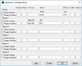
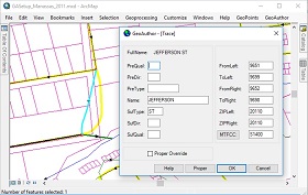
The powerful features in GeoElections synthesize the strength of ArcMap providing a set of tools and data management techniques that subscribe to the most demanding definition of “Best Practices”. ICW’s goal has always been to create software that does not require a GIS Analyst in order for a member of the elections staff to manage, create, update, maintain and map data specific to the needs of the office along with the power to update the voter registration system with data of the integrity produced with GeoElections. ICW makes GIS available to non-GIS staff while increasing the productivity of the most talented GIS Analysts. For example, managing street names is simplified with the GeoAuthor Change Name function, one of the functions included with GeoElections. Select a street segment and activate the Change Name dialog box which offers context sensitive Help. One can easily edit the naming for one or many street segments, a primary and up to 5 alternate street names using the Global and Proper Override functions.
|
|
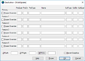
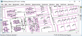
While Change Name provides a workflow to manage one or all segments with the same name, MultiUpdate provides a workflow to manage some segments, one to thousands. Select the segments to
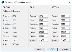
edit and fill in the dialog box updating ZIP Codes, MTFCC values or revert graphics. As segments are edited, GeoAuthor bolds the segments, providing a visual confirmation of the edited segments. Revert graphics rolls back symbology to a pre-edit state. The Create Intersection dialog box is accessed after the user has selected a segment to split, thus creating an intersection along either a line or polyline. In this example, a line has been selected and GeoAuthor will distribute the addresses 50-50. The user may edit the ranges to match ground truth.
If this had been a polyline with a 40-60 split, GeoAuthor would have distributed the addresses proportionate to the resulting line lengths. The Trace function requires the user to snap the ends of a segment in the table being edited to a backdrop from which to conflate both geometry and tabular attributes. Then select the segment to be edited and activate the Trace function.
The ability to conflate maps A and B creating map C is a powerful technology. The ease with which GeoAuthor facilitates this powerful technology once again brings GIS into the hands of the nontechnical user and makes the most accomplished user more productive. While GeoAuthor manages linear networks, GeoPoints provides end-users with the tools to create, edit, conflate and maintain databases of discrete points. GeoPoints can be polling places, commercial sites and residential locations from single family to multi-residential. GeoElections works with both point and ranged addressing as independent databases or a hybrid database.
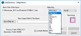
With the strong foundation GeoAuthor and GeoPoints provide, GeoElections adds a host of functions making elections professionals more productive and increase the range of services they are able to provide to the voting public and
candidates alike. MapMaker, Ballot Maps, Legal Desc, DOJ Reporter, and interoperability with voter registration systems provide a view to the power. |