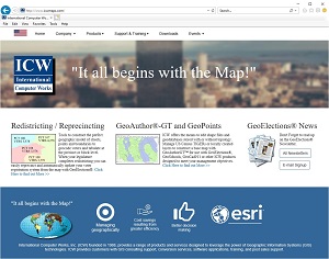
 "It all begins with the Map!"
GeoElections News
 Temple Terrace, FL www.icwmaps.com VOL. 17 NO.2 -
  $.50
$.50 
|
After two decades hosting a website crafted with the state of the art technology in 2000, www.icwmaps.com, ICW now has a new public face on the web. After several weeks working with new technology and employing best practices, ICW has a new presence on the web.
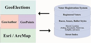
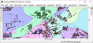
Along with our new website, ICW has developed several products designed for use with ESRI’s ArcMap for the people who manage elections from county to county and state to state. GeoElections has been available for over two decades, well received and in use across the country. St. Johns County, FL is the first county to deploy the ArcMap version of GeoElections. While the first deployment of GeoElections in ArcMap uses GeoAuthor and GeoPoints, ICW has now released GeoAuthorGT and GeoPointsGT which can also be used with GeoElections. GeoAuthor was designed to work with the US Census TIGER/Line Shapefiles making edits to both geometry and tabular data while maintaining TIGER topology. Ground truthing TIGER yields great rewards and our products include conflation tools for this purpose. The P.L. 94-171 version used by state legislatures for redistricting is of significant interest in the elections industry. These files will be released in January of 2021. GeoAuthorGT manages geospatial databases built from numerous layers of GIS data. Most of these layers are locally developed consisting of roads, hydrography, railroads, political boundaries, precincts, etc. The GT designation is an acronym for Geospatial Topology. TIGER data can be incorporated into the database to provide an ideal solution for working with the redistricting data produced by a state legislature in 2021, 2022 or later. Within the US, 24 states require their respective elections officials to build precincts upon US Census geography. While the other 26 states are not required to use Census geography, the elections authorities do have guidelines for precinct creation. For example, some of the constraints may require the elections authority to follow manmade and natural features to define precinct boundaries and/or to nest within various political subdivisions. Both GeoAuthor and GeoAuthorGT can be used to address these numerous guidelines for precinct creation and in conjunction with GeoElections bringing efficiency and accuracy to the Elections office. In any event, one of the most compelling arguments for the use of an ICW solution set can be observed in the ability of GeoElections to interoperate with the voter registration system as illustrated below.
Historically elections officials would attempt to match up new Congressional, State Senate and House boundaries with local paper maps, access property appraiser’s data or some other resource to manually correlate addresses to the new boundaries. Attempt to build precincts. Then manually enter the new boundaries into the street maintenance module of the voter registration system with traditional data entry hoping they matched the addresses to the boundaries then spend the next four years correcting errors. GeoElections automates all of this labor providing data integrity. |
|
GeoAuthorGT, GeoPointsGT And GeoElectionsGT The people at ICW a proud to announce the immediate availability of the GT solution set for elections officials not required to use TIGER/Line Shapefiles in the construction of precincts. GeoElectionsGT interoperates with the voter registration system (VRS) to pull voter data from the VRS into GeoElectionsGT for geocoding and conversely to transfers data to the VRS. For example addresses and geopolitical boundaries for each of the addresses which will accurately dictate the ballot style each household will receive.
NSGIC is an organization of GIS experts, recognized nationally in GIS, IT policy, data creation and data management.1 People at NSGIC asked, “Does America’s electoral system know where each voter resides? By and large, yes. But not nearly well enough to correctly place every voter in the right voting district and avoid election errors.” “When voters are given the wrong ballot, results are contested. Controversy, legal battles, and even costly do-overs follow. With a presidential election on the horizon, and a redistricting process following shortly on its heels, there has never been a more important time to be able to correctly place voters in the right voting districts.” The author is spot on where down ballot elections are won and lost by 5 or 10 votes. These errors can be avoided with the data integrity delivered with GeoElections and its interoperability with your voter registration system. GeoElections users can attest voters receive the correct ballot because of the data accuracy attained with the map editing tools and the integrity of the address data to boundary relationships.
Interoperability facilitates updating the voter registration system efficiently and economically.
________________________________________
1https://en.wikipedia.org/wiki/ 19th Annual GeoElections Conference December 2nd, 3rd, and 4th, 2020 at the Embassy Suites Hotel located at 10220 Palm River Rd., Tampa, FL 33619. Get ready for the new P.L. 94-171 TIGERs. The same files your state legislatures will use for redistricting. Also to be presented technical topics using GeoElections. Users should bring their projects on a notebook for a project workshop using your own data.
The GeoElections Conference presents a unique opportunity for elections staff to obtain training in the use of GeoAuthor, GeoPoints and GeoElections. Guest speakers are welcomed to speak to a variety of topics related to product solutions and Census data. Meet your counter parts from other counties from Florida and other states. Learn how other professionals solved problems using GeoElections. The GeoElections Conference presents a unique opportunity for elections officials. We focus upon the successful use of GIS in the elections process dictated by the best practices in elections administration. Dinner and Top Golf.
Work hard and plan to enjoy driving off an upper deck. Take your frustrations out on a golf ball with qualified instructors. For more information about the GeoElections Conference visit: www.icwmaps.com and Events>Conferences.
See you in December! |