
 "It all begins with the Map!"
GeoElections News
 Temple Terrace, FL www.icwmaps.com VOL. 18 NO.1 -
  $.50
$.50 
Which One Do You Want You’re County To Work With?
Which One Do You Want You’re County To Work With? The definition of the word conflation according to The Cambridge Dictionary, “conflation (noun) is the act or process of combining two or more separate things into one whole, especially pieces of text or ideas.” The Census Bureau uses conflation extensively to maintain concurrence with existing data.
Within the design of GeoAuthor, ICW has made significant endeavors to enhance the data management of GeoAuthor to enhance the creation of the finest tools available with which to create mapping for elections. The illustrations below are an example of conflation before and after editing with GeoAuthor.
 | 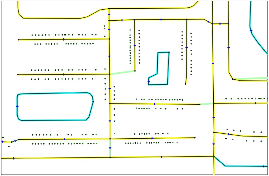 |
Where Is the Data? The people at ICW recognized early on in the update process, some of the best data lives in the existing model. Municipal boundaries, School Boards, County Commissions Districts, Congressional, State Senate and House Districts, Special Taxing, Precincts and many other districts have found safe haven within existing projects. As good as a project may be, there is better data to be used in the conflation. The Property Appraiser provides an excellent source for obtaining horizontal control of where a line exists. For corner lots, does the house face north or east in this example? Where does the voter live? In homesteaded communities, the lot can provide reasonable knowledge of the voter’s home. The service your E-911 provides can include a center of street network along with discrete addressing. Both of these files can be used in conjunction with Property Appraiser parcel maps. Reasonable information can be drawn from the two agencies. However, street names can be a problem. The SOE, E-911 and the Appraiser use variants of the same street name, conflict can arise. |
One always has access to www.usps.com to select the correct names. When in search of a neighborhood, google maps can provide a means for locating an address. To the on line mapping list one can add Bing Aerials. Both of these products afford the means of identify the general location of an address. Other services may be available from your county GIS Department. Frequently they will be able to provide resources that may overlap the Property Appraiser and E-911 staff. Additionally, they may have access to special taxing districts and other taxing authorities one wants in the map. Even if your County does not have an existing project, one can be created using data from the sources listed above. Virtually all new counties start the mapping without a project to begin with. ICW has worked with data from different agencies in order to complete the necessary mapping design for elections. There is a special context in which the people at ICW work that demands the correct data in order to construct the ideal Elections mapping. Once the model is created with GeoAuthor, adding the power of GeoElections to interoperate with your voter registration system and you have built a powerful solution for mapping.
|
The Art of Conflation | ||||
The art of conflation is a term borrowed from the study of literature. It is the process where combining two variant texts into a new one. GIS technology is more modern than other disciplines. Thus, borrowed names determine other disciplines. It has been said the silver tuner for mapping is "conflation". To this end, the people at ICW have spent a great amount of time and energy developing specific tools to assist with the next decade's base map. Tools such as Change Name, MultiUpdate, Change Attribute, and Trace along with other numerous features are wrapped up in your software. Following is a portion of the full dialog box from the Change Name. This feature is an example of updating one or all of the name(s) in the database. The Global Change and Proper Override features allow one to refine feature options. 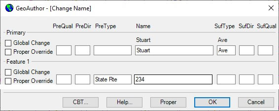
While not illustrated, similar to the Change Name, the MultiUpdate function allows the user to Change Names, ZIP Codes, MTFCC and Revert Graphics. Below is an example of the Change Attributes dialog box. One can update a segment at a time. Both update Address ranges, ZIP Codes and the MTFCC values change also be update. 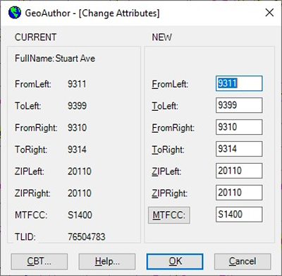 | Below is an example of the Trace function. The yellow line represents the proper base line we want to conflate with. The second line is our TIGER, which we are going to adjust. Select yellow line and activate the Trace function.
The Trace dialog box will pop up illustrating the attributes of the segment included with the line segment for final review. Once the segment has been added, the map will appear as Illustration 2. When you are presented with the maps from the US Census Bureau to work with, you will use the tools in GeoAuthor to convert the Census data to match your current map. Each line within the new data should match the geometry of your existing line work. New boundaries will be provided that replace the districts you have been using to make up municipal annexation, special taxing districts and other boundaries. With the P.L.94-171 a key boundary will remain as submitted to the Census redistricting program. This district will be your voting district boundaries and wards. The Census worked with the states to ensure they have the data summaries tabulated to the necessary geography to facilitate their legislative redistricting. This feature is important to place your voters. Blocks are areas define by streets, roads, streams, railroad tracks, and by nonvisible boundaries, such as selected property lines and city, township, school district, and county limits and short line-of-sight extensions of streets and roads. At the extreme, blocks can encompass hundreds of square miles. In all instances, blocks will designate all areas for federal, numerous state and county regions. The functionality contained in GeoAuthor will save many hours of editing with alternative software. The art of conflation imbedded with your ICW software will work to solve your problems. | |||
