
 "It all begins with the Map!"
GeoElections News
 Temple Terrace, FL www.icwmaps.com VOL. 21 NO. 1 -
  $.50
$.50 
Editing Tools Design for Elections!
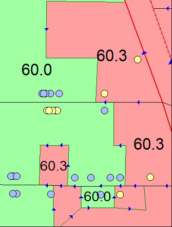
Mapping your election data before, during and after an election is critical to serving your constituents. Along with the correct precinct assignment you want to be sure everyone has been given the correct assignment. In our illustration, the yellow dots belong to precinct 60.3. There are several voters on the south side of the horizontal street. These are voters that need to be corrected in the voter registration system. Get Voters Get Voters is designed to simplify the process of obtaining a voter file from the voter registration system. There are numerous benefits in working with your existing voters. If the file has not been geocoded this is a great way to confirm the voters fall into the correct precinct after geocoding. Working with the block table used in GeoElections, one can run an integration that the voter’s precinct assignment matches the assignment for the block they geocoded into. When the two assignments to not match fix the problem. This is a simple point in polygon analysis. Address Dictionary GeoElections uses the linear network to create a block table. The block table is made up of polygons that carry data such as Congressional, House, Senate, and other units of coverage. Along with the ranged addressing and/or discrete points, these features can be used to create a file to be imported to the voter registration database. Alternatively, the file can be created to work with Microsoft Word as a paper precinct locator. This is intended for use as a source for creating and/or updating the VR street file. The Electronic Dictionary can operate in two modes:
The user can select an Entire or an Update dictionary. The first time the dictionary is run an Entire is executed. The Update can be used subsequently. |
Street Map Geocoding In order to geocode your voters, you need a map. This map can be made up of ranged addressing. Street segments with a from and to addresses on each side of the streets. Or the streets can be discrete points. One for each household. The geocoding process matches the voters to a line or point. This is the process of geocoding.
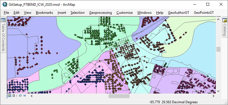
TIGER/Line Shapefiles GeoAuthor was designed to work with the US Census TIGER/Line Shapefiles making edits to both geometry and tabular data while maintaining TIGER topology. Ground truthing TIGER yields great rewards and our products include conflation tools for this purpose. The P.L. 94-171 version used by state legislature for redistricting is of significant interest in the elections industry. New TIGERS files will be released in January of 2026. Visit our GeoElections Conference in December of 2025. |
GeoAuthorGT, GeoPointsGT And GeoElectionsGT The people at ICW a proud to announce the immediate availability of the GT solution set for elections officials not required to use TIGER/Line Shapefiles in the construction of precincts. GeoElectionsGT interoperates with the voter registration system (VRS) to pull voter data from the VRS into GeoElectionsGT for geocoding and conversely to transfer data to the VRS. For example, addresses and geopolitical boundaries for each of the addresses which will accurately dictate the ballot style each household will receive.
NSGIC is an organization of GIS experts, recognized nationally in GIS, IT policy, data creation and data management.1 People at NSGIC asked, “Does America’s electoral system know where each voter resides? By and large, yes. But not nearly enough to correctly place every voter in the right voting district and avoid election errors.” “When voters are given the wrong ballot, results are contested. Controversy, legal battles, and even costly do-overs follow. With a presidential election on the horizon, and a redistricting process following shortly on its heels, there has never been a more important time to be able to correctly place voters in the right voting districts.” The author is spot on where down ballot elections are won and lost by 5 or 10 votes. These errors can be avoided with the data integrity delivered with GeoElections and its interoperability with your voter registration system. GeoElections users can attest voters receive the correct ballot because of the data accuracy attained with the map editing tools and the integrity of the address data to boundary relationships. Interoperability facilitates updating the voter registration system efficiently and economically. |
24th Annual GeoElections Conference December 10th, 11th, and 12th, 2025 at the Embassy Suites Hotel located at 10220 Palm River Rd., Tampa, FL 33619. Get ready for the Census BBSP using 2025 TIGERs. The GeoElections Conference presents a unique opportunity for elections staff to obtain training in the use of GeoAuthor, GeoPoints and GeoElections. Guest speakers are welcome to speak to a variety of topics related to product solutions and Census data. Meet your counter parts from other counties from Florida and other states. Learn how other professionals solve problems using GeoElections. The GeoElections Conference presents a unique opportunity for elections officials. We focus upon the successful use of GIS in the elections process dictated by the best practices in elections administration. Dinner at Top Golf.
Work hard and plan to enjoy driving off an upper deck. Take your frustrations out on a golf ball with qualified instructors. For more information about the GeoElections Conference visit: www.icwmaps.com and Events>Conferences. See you in December! | |
 The same files your state legislature will use for redistricting. Also, technical topics are presented using GeoElections. Users should bring their projects on a notebook for a project workshop using your own data.