 "It all begins with the Map!"
GeoElections News
 Temple Terrace, FL www.icwmaps.com VOL. 7 NO.2 -
  $.50
$.50 
|
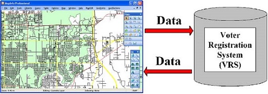
TMT© Version 7.0 With Custom GeoCoder The TIGER To MapInfo Translator (TMT©) from ICW was the gold standard for translating TIGER/Line® Files to MapInfo TAB through the 90’s. The next generation TIGER translator, UTT© replaced TMT© with some overlap The TIGER Update Software (TIGERUS©) allows the user to easily make topologically correct edits to TIGER/Line® Files from 1995 through the 2006 Second Edition and consists of the MapEdit ToolKit© and UTT©. With the introduction of the TIGER/Line® Shapefiles by the US Bureau of the Census in March of 2008, ICW introduced GeoAuthor® for working with the topology of this new generation of digital geography. While the TIGER/Line® Shapefiles can be translated directly from their native shape format TMT© also includes a custom GeoCoder that utilizes the left and right side ZIP Codes contained with the address data. This eliminates the need for ZIP Code polygons when geocoding to the roads TMT© builds. WebElections™ With Enhanced Resolution The latest enhancement to WebElections™ provides higher resolution for Precinct Labels. This is of special importance to larger urban counties with approximately 1,000 precincts. Following are sample views of Hillsborough County: The first view illustrates the entire county with a square outlining the approximate view displayed in the map window of the following view: WebElections™ is a module of GeoElections and provides precinct level reporting through interactive precinct maps. Additionally, the standard reports (i.e. tabular, bar chart, etc.) are also provided. Results can be viewed from desktop computers and cell phones allowing you to reach the widest audience. Reduce Work Load While Increasing Integrity of Your VRS During the months of December 2010 and January 2011 it is expected the US Census Bureau will release the new TIGER/Line® Shapefiles which will contain the new 2010 census block boundaries. This data is the geographic component of the PL 94-171 data which will be used for redistricting across the country. For elections offices currently using GeoElections it is strongly recommended you make the interoperability connection between GeoElections and your voter registration system (VRS) now before you set up a new GeoElections project with the next generation of TIGER® and certainly before the November 2010 general election.
If your office is already using this connection with the staff knowledge and understanding to get the full return on your investment, then you are prepared for the rigors that lay ahead. If this is not the case, you have time to leverage all of the investment you have made in both GeoElections and your VRS to work for you with the accuracy and data integrity your constituent community expects of you and the office you represent. The use of GeoElections as an interoperable application with your VRS provides numerous benefits, not the least of which is improved integrity in the data that drives ballot delivery. The data relationship between your VRS and GeoElections is a two way street. The VRS can provide the following data for use within GeoElections: 1. The Get Voters function in GeoElections pulls a voter file from the VRS as a native MapInfo TAB format ready for geocoding with GeoElections. With the voters geocoded, one can run a standard query to identify any voters that have been assigned to the wrong precinct. If there are errors, the results give the analyst an opportunity to investigate and make the necessary corrections. 2. GeoElections will tabulate the number of geocoded voters in each Census block. The Census blocks can be aggregated to create or modify precincts. As the analyst adds blocks, the system will increment the total number of voters in a precinct and decrement the number of voters from the precinct to which the block was previously assigned allowing “what if” planning. 3. Copies of files from you VRS containing your polling places and poll workers can also be geocoded for use in creating maps and providing assistance in poll worker recruitment and assignment. Alternatively, the data flow from GeoElections to your VRS provides but is not limited to the following data and benefits:
The combination of GeoElections with your VRS cannot be matched for accuracy and labor savings in meeting the demands placed upon your office. Especially when time is critical and accuracy is not an option. |